Bagging Osceola and East Peak with AMC

  Saturday, Jun 1 2019:   A perfect day for a mountain trek -- mid-sixties temps, with high overcast which didn't block views and made photography that much better in the diffuse lighting.  And as an extra bonus, according to some sources June 1 is National Go Barefoot Day!  Not that it would change anything for me...

I was prompted to select Osceola for a couple of reasons -- one was that I *think* I had been up it decades ago, but didn't remember much about it. Today an AMC group trip was scheduled to go up there, but I wasn't sure I had it in me to be awake and functional early enough to drive up and make their start.  I figured I'd just go up and do it on my own volition and schedule, and maybe run into them along the way.  As it turned out I arrived at the trailhead just after they'd vanished into the woods, but I had to deal with a couple of things before I could start up.


[Images are linked to larger hi-res copies.]
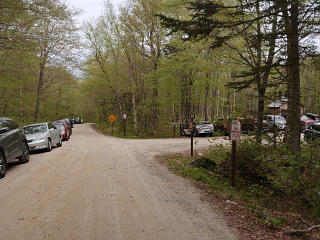
Full parking at trailhead I had also forgotten that Tripoli Road turns into gravel for much of its length, so that affected my drive time.  The parking lot was basically full, and more cars lined the road for quite a distance ... I managed to slot into a sketchy space that dove into sort of a gully near the entrance, and hoped I hadn't put myself in a situation of being stuck there when trying to back out later.  Then I realized that there was a parking fee, and had to fill out the little envelope and put the hang-tag in the car, get Picaridin onto myself as it was still high black-fly season, get organized, etc ... so I was probably about 15 or 20 minutes behind the AMC group by the time I finally shouldered my pack and hit the trail.

Plenty of rocks early on the trail An avenue of rootiness
Like so many well-traveled White Mountains trails, the path was on the rough side and peppered with rocks and roots.  The rocks got bigger later on, too.  I love rock-hopping along stuff like this, and feeling every little nuance of surface as I go along happily unshod and almost dead-silent.  The trail runs along the right-hand side of the rise for some of the way, making the land on the left substantially higher than the land on the right.  I was amused by the rather uniform rank of silver birches desperately clinging to the drop-off -- they're probably an essential part of keeping the trail from completely eroding out here.

Lots of storm damage in one particular area Along one particular stretch there was a massive amount of obvious storm damage and blow-downs, leaving the area eerily open to the sky.  The best theory would be that a "microburst" had happened here a while back; some of it had been sawed clear by the forest service folks, but I still had to worm around and under a few obstacles.

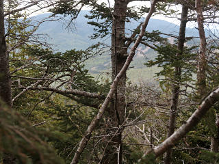
Glimpse of Waterville Valley through trees As I gained more elevation, I could see across to Waterville Valley and the ski area through the trees.

  I blasted along at my usual solo pace for a while, and managed to catch up to the AMC group about halfway up to the summit.  They had just stopped to regroup, and I came steaming up behind.  As it's their trail-courtesy habit to move aside for other hikers to go by, I easily passed through the group and met the leader, and explained how somewhat complex logistics had kept me from officially signing up for his hike but I'd decided to just come out and do the mountain on my own.  I didn't even get into explaining the barefoot thing before he said I was welcome to join them, but there was quite a bit of "omg" and discussion with the group about my footwear choice anyway.  The leader was totally cool with it, especially upon observing that I was already well into a significant hike and doing just fine.

I walked with them for a little while and chatted with the leader about various stuff, from other barefooting adventures to internal AMC committee machinations to the joys of "mud season", but then opted to keep going more briskly ahead of them and perhaps re-connect at the summit.  The AMC hike had left bagging East Osceola, the additional peak a mile or so farther along, as an option depending on how the group felt -- and I figured I'd evaluate my own state before making that decision as well, and maybe accompany them on that piece of it.


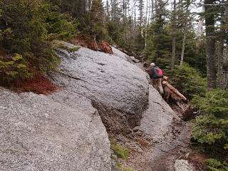
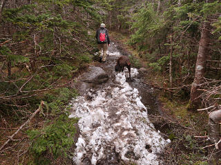
Wet slanted slabs Remains of some snow
While I was introducing myself to the AMC group another solo hiker had passed through the group with his dog, and after a bit farther I caught up with him and we hung together for the rest of the way to the summit.  He provided scale for a couple more pictures, notably of the many large *wet* slanted slabs that form part of the trail.  One can opt to take the "high road" here or stay down in the muddy gully at the bottom; I could usually take the high road because the grip of my soles on the nicely-textured rock was quite solid, and I could feel exactly how close I might be to slipping the whole time.  That's one of the best advantages of nothing between the sole and the terrain; all those mechanoreceptor nerve endings come into play doing exactly the job they are there for.

As things leveled out shortly before the summit, we found some leftover snow!  Not exactly "monorail" as it was all rather soft, but entertaining to slog through especially considering it was still here in June.  It was familiar because I'd been on some of our local smaller-scale monorail equivalent during my winter Fells hike that year, over frozen sections mashed down and solidified by other hikers, where I observed that temperature-equalized soles provide astoundingly good grip directly on ice.


The obligatory benchmark Having summited, I could relax a little, and include the obligatory noting of the usual survey benchmark found on many of the higher peaks.  I debated how long I should wait for the AMC group to appear; I was doing fine and all set to head for the "extra credit" leg to East Osceola.

AMC group arrives at summit That question was answered less than ten minutes later, when the AMC group appeared.  But now they wanted to pause and hang out to admire the summit view and grab a little food and get a bit of rest before the next piece.

A special summit surprise! This was well worth sticking around for, because not only had someone supplied "summit cookies" which I learned is a long-standing tradition, the leader had brought a special surprise: summit watermelon!  [aka: more weight for his pack all the way up.]

Whole AMC group, with watermelon Since I wasn't officially part of the group, I volunteered to take a good group summit shot of them [with watermelon] and send it to the leader later.

For this shot I swung the camera left a little to include the east peak, to the left behind them, basically the dark green mound above the white dog.


East Osceola, the next target The mood of the group, as well as myself, was clearly rarin' to get over there, which would involve the intervening mile of ridgeline down and back up.  Midway we would encounter a salient steep terrain feature called "the chimney", situated about where the obvious rocky drop-off is near the center of this shot.

Beyond that we could also see a bit of the Kancamangus winding its way around in the next valley.  The overcast stayed high, so we had great views from here!  All the way up to Washington and down to the Waterville ski area.


Starting down East Peak trail Soon we started down the East Peak trail, which begins a bit steeper on the descent than the main trail coming up.

Plenty of mud On the flatter sections, there was plenty of mud!  Trail use guidelines recommend that hikers go straight through spots like this instead of trying to dance around the edges, as it causes less trail erosion.  But most aren't willing to get their boots that wet, since it would make for fairly uncomfortable foot conditions for a long time afterward.  That's another advantage of going unshod -- I could barrel right through the middle of the mudpuddles, and my natural-born boots would dry out almost immediately thereafter.

Down the Chimney bypass Finishing the chimney bypass descent
There are two ways to navigate the Chimney.  The Chimney proper is sort of behind the trees in the second picture, above the guy in the green shirt.  Since some other hikers were coming up it at the time, we went around via the somewhat easier bypass to come down.

Complex microcosm under a root ball East Osceola is pretty much treed in and there isn't much in the way of views, so visually it wasn't particularly noteworthy but it *did* count as another 4K for anyone working on their 48.  We took a brief break there for more snacks and a couple of "separations", the hiker term for wandering away to tend to personal needs, and then started back.  Along the way was this interestingly complex microcosm under an upturned root structure.

The New England woods really are a celebration of life building on top of life, in some truly fascinating ways.  I find the numerous varieties of moss particularly interesting.


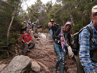
Starting up the Chimney Up the Chimney for real
Now it was time to scramble *up* the Chimney, which most of us decided to do for real this time.  Two or three went up the bypass anyway, but if nothing else that gave us an aggregate bandwidth increase.

Sketchy rock chunks on Chimney There are plenty of holds, but the attachments of some of the rock layers and pieces look pretty sketchy, like they could just pull right out and fall.  This section probably loses material in every freeze/thaw cycle.

Playing in the snow! Since this was the north side of the ridge, there was still a surprising amount of snow laying around under the denser trees.  Had to play in it!  I described the mechanics of snowfooting to quite a few people that day.

Another group food break We returned to the main summit, and took a slightly longer food and rest break before starting down.  Sunlight was peeking through the overcast here and there, making some gold patches across the valley.

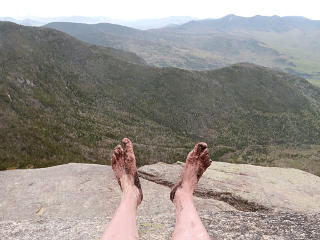
Muddy feet over the valley At this point I was pretty mudded up, but my feet felt great.  This shot is my answer to a photo that someone contributed to Google Maps, with his boots hanging out over the void.  [For some reason "Nat" dropped it at the trailhead marker, instead of the summit.]   There were plenty of opportunities to clean up a bit at stream crossings on the way down, so I didn't really bring any of the mountain home with me in the car.

I wound up staying with the group for the descent as well, enjoying the somewhat more leisurely pace and more opportunity to look around, even if it was punctuated by the incessant clack-clack-clack of their hiking poles on the rocks.  [Here's a 9-second video showing what I mean.]


    An old situation finally resolved

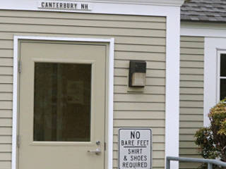
Welcome, my foot! New Hampshire has a few state-managed rest areas that they refer to as "welcome centers", providing tourist info and restrooms among other things.  On my way up for this adventure, I stopped in at the one near Canterbury to return my "coffee rental" and also to see if some unwelcoming signage had been removed.  This is a taxpayer-funded public resource, and this sort of discrimination is totally inappropriate and probably illegal.  After last year's trip when I saw this and asked the people staffing the desk inside for supervisory contact info, I went to lodge a complaint with the state tourism office in Concord.  People there had been hard to reach, but I eventually got a suggestion to file a detailed complaint via email to the department director.  So I duly sent this in, but never received any kind of response.
Since I had never made it back up north for the rest of 2018 and couldn't check on any progress, this run up to Osceola was my next chance.  Both nasty signs were still in place, so it seemed like my efforts had fallen flat.  I went in anyway, ready to defend myself against some ignorant lackey and ask if they'd rather I go pee in the pet-relief area instead.  The lady behind the desk, who could clearly see all of me, greeted me with a cordial "good morning!" as I headed for the human restroom, and wished me a nice day on the way out.  No mention about footwear; she clearly didn't care.  I actually recognized her from the previous visit, too.  Still, it had been another several months of those damn signs passively misinforming the public that there was something wrong with bare feet.

So the next workday I called in to complain again and ask why the signs were still there.  All of the people in Concord I had contacted before seemed to no longer be with the department, but the new guy in charge of the rest areas returned my call a little later.  And that's when I got the great news: the signs were not supposed to be there at Canterbury anymore; in fact, he assured me that any such signs referencing footwear were supposed to get TAKEN DOWN at all of the rest stops statewide and not return.  My original complaint had evidently had its effect after all, I just hadn't gotten any feedback about it.

Thus, another little triumph from this trip, even if the Canterbury crew has been lax about their site improvements.  When I told the guy that I'd stopped there and then continued on and barefooted Osceola and had a great time, he sounded quite impressed.  I promptly reported this favorable development back to the mailing list, where a thread about highway rest areas in general had gone by a couple of months before.


Anti-barefoot sign finally REMOVED Then on another trip north about a month later, the sigh by the main entrance was indeed gone!  Nothing left but a couple of small holes where the bolts had been.  A definite improvement, but the similar second sign was still up on the wall of the separate snack-machine building.  I went in and this time, directly addressed the situation with the desk attendant -- she hadn't even remembered that there *was* a second sign, and came outside to look.  We wound up having a quite pleasant conversation about all of this, and she promised to call the administration in Concord and get the "official word" to get that one taken away as well.  She seemed to understand and appreciate why it was important, to help stop feeding those fake-news myths against barefooting to the visiting public.
Based on my own and others' observations in the 2018/2019 timeframe, the general trend seems to be that most states have become more sensible and welcoming in this regard -- especially if they depend so heavily on their tourism trade.  If their rest-stops had such signs in the past, they're mostly gone now.

_H*   190602, and updates